
31st July 2016
And so, after a lot of excitement, trial and tribulation and good dose of adventure I roll into Halls Creek. First thing … the Shell service station, a meat pie and an iced coffee. The attendant asks “Any fuel?”, it is a service station after all, to which I reply, pointing at my meagre purchases “These are my fuel”. Am not sure, perhaps it was the light, I could be mistaken, but I thought, thought I caught a slight movement at the corners of her mouth. For sure though, no smile made it to her eyes. It is a busy Sunday afternoon and I’m sure she’s just a wee bit tired of the whole tourist-demand thing.
I get her point as I sit on the short pavement and lean against the wall of the building. A long line of 4WD and their various iterations of trailers line up to access the bowsers. A busy day.


Making my way over the road to the Halls Creek information board just outside the closed Tourism Office I try to decipher what accommodation options there. Three apparently: The Kimberley Hotel, the Best Western Motel and the caravan park. I really need a place indoors. Not that I’m tired of life in a Hillebergs’ single-person Soulo tent. More that I need to clean everything. Dust is everywhere: my travel clothes, all my panniers and bags are covered in it, the Goal Zero solar panels are a nice dark red a mix of their original black material ingrained with fine red dust, the tent feels like fine grained sandpaper, my sleeping mattresses, I mean everything. Doable in a caravan park. Far, far easier when I have a room.
The caravan park is just across the road from the Kimberly Hotel. For 14$ per night I can place my tent on patchy grass with a discernible slope. Some shade. Some. The Kimberly Hotel is quite a salubrious place. They don’t have a room available for three nights straight and there’s some doubt about the third night. For the second night only an ‘apartment’ is available, for 365$ per night. Errr …
The motel can accommodate me for 160$ per night. I balk at the price. It’s a lot higher than I expect. Jenny sizes me up and comes up with an alternative: a room with shared facilities in the staff dongas for 100$ per night. Best price in town, apparently. I take it.
Halls Creek is a ‘dry’ town. The only takeaway alcohol available is beer with an alcohol percentage of 2.7%. Or less. Prohibition ala 21st Century style aimed to combat the propensity for alcohol abuse mostly among Australia’s First Nation population. Whilst I’m sure that non-availability addresses the immediate problem of easy access, prohibition tends to promote inventive initiatives to address the lack of supply meaning abuse is likely to continue albeit at a slightly lower pace. And I haven’t been able to identify the parallel policies and programs to help educate the vulnerable target group of the prohibition on how to enjoy alcoholic drinks with moderation.
Since I’m now a resident of Halls Creek I can buy from the motel’s bar and restaurant an amount of alcohol they believe I can realistically drink in one day and not get outlandishly drunk. At full bar/restaurant prices. I drink in moderation.
01 August 2016
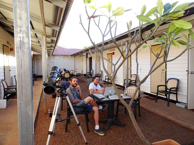
As is my habit I wake around 0500 and are busy arranging things for cleaning by 0700.
A large trough along the outer wall of the staff ablution building is perfect for cleaning the large bulky objects like the panniers, bags, tent and other chunky equipment. The washing machine is huge, costs 5$ per load and can pretty much fit everything I either wear, sleep in and the soft cloths I use for cleaning. My two sleeping mattresses require a flat clean surface to lie on (with no spiky things), a bucket with soap and a cloth to wash and wipe them down. The electronics like the Goal Zero solar panels and power supply, the computer, GPS’s, camera, headlamp, phone need a softer more delicate approach largely lacking water. My Keen sandals and Shimano cycling shoes get a looong soaking before a substantial scrub and rinse.
It takes the whole day and my gear occupies all flat surfaces in my room including the floor, two tables outside and a good chunk of one of the ubiquitous clothes-hoists popular in Australia. A mild breeze, +30oC temperature and an endless blue sky results in everything being dry pretty darned fast. Quite a contrast to the same task after a hike in the north of Scandinavia which can take days to dry everything thoroughly.


The phone rings. Scott H Murray. My good hyper friend from Jabiru, with whom I enjoyed a tremendous trip to the Cobourg Peninsula in Arnhem Land. “Where are you?” he asks. Something about the background noise alerts me that this may be a loaded question. “Halls Creek” I answer. “We’ll be in Halls Creek in a couple of hours” he responds with laughter. Scott and his partner Evelyn are on the homeward leg of a Kimberley-north west Australia trip. Did I want to join them on a new-moon photography trip to Wolfe Creek? is the big question.
As it turns out I can’t join them. My cleaning and organising barely begun it’s not really possible to join them despite my enthusiasm for such a trip.
On the other hand they are heading north planning on visiting Purnululu, an iconic World Heritage listed geological phenomenon. Check out: https://parks.dpaw.wa.gov.au/park/purnululu

And they will be back in Halls Creek the day I plan to depart. I’m in for that. We’ll work out how to fit Dreamer and Zi-Biddi and the rest on their already well loaded Toyota 79 Series dual-cab. It also means I’ll get a fast-tracked ride to Kununurra, speeding up my Epic by at least a week.
3 August 2016
It takes but half an hour to unload Scott’s Monster and reload it accommodating Dreamer + Zi-Biddi, all my bags and to make space on the back seat for me. A bit of shopping and a quick lunch and we’re off. At 110 kilometres per hour we travel a kool 30 kilometres more per hour than I’d reasonably expect to achieve in a day’s ride.

We stop to take some photos of Boab trees, one of the symbols for the Kimberleys and related to the baobab of Africa. HUGE trunks presumably related to water management in a water-stressed region. They lose their leaves in the dry season to minimise water loss. A sort of reversed deciduous strategy to broad-leaved trees in colder-climes.


Purnululu is accessed via a 56 kilometre of track with the usual fierce reputation, across Mabel Downs station’s property. So fierce that there’s an industry sprung up whereby people can leave their phenomenal 4WDs at the gate and access and tour Purnululu from the comfort of huge-wheeled 4WD mass-tourism buses. Julie and Mark who I met whilst camped at Nyarna took this option. I’ve been told tales of cyclists crawling the road taking seven hours to complete the 56 kilometres. I’m really curious how ferocious the track is.
The gate’s a busy place. Twin axle caravans and trailers are not permitted to travel the track, obliged to remain at the caravan park but a kilometre from the gate. Scott, being a well-versed gravel-road/track survivor, lets the tires of the Monster down to soften the ride for us and ease the pain of the track from the relentless abuse of the constant travel of monstrous 4WDs.


From a cycling perspective the track is pretty good. There’s plenty of tight bends which slow the 4WDs well down but which wouldn’t make a difference to a cyclist. The corrugations are small since the large heavy vehicles can’t get up any decent speed because of the sharp turns. Towards the end of the track there are quite a few short steep inclines and declines which would slow a cyclist down. But they are neither particularly long nor that steep, unlike they of the Munda Biddi and the Mawson trails. There also some short sections of soft sand. And remember, sand is the bike killer. But such sections are not long. I almost, almost regret not riding the track. Magnanimously Scott offers to drop me off, whilst he and Evelyn go ahead. I’m promised they will have a nice cold beer for me ready by the time I arrive. Graciously I thank them but decide to remain snug if a bit bouncy in the back seat of the Monster. We do several stops to check that the load on the back is still secure, and to get the odd landscape snap.


I reason the track has a reputation it doesn’t otherwise deserve.
After registering at the Visitors’ Centre and paying the park-fee, we end up at the Kurrajong Campsite. Scott has the little blue tent I bought for 15$ for my Top End adventure waaay back in May. I decide to try it here in the Kimberleys. Then we start on the beers whilst watching the sun change the impressive escarpment of the Bungle Bungle Range into all manner of reds and oranges.
Very soon we lament the campfire prohibition as by 1900 the temperature is down to 4oC. We are freezing sitting outside. I end up putting on pretty much everything I have including long pants and multiple layers on top. I wonder if I’ve been a bit premature sending back to Perth all my thermals from Halls Creek. If it’s 4oC now, it’s likely to dip below 0oC during the night. And my little blue tent has but a single layer, unlike the more robust Soulo.
4 August 2016
It did indeed dip below 0oC during the night. It was but 2oC in my little blue tent. I had to zip up my outer sleeping bag but was otherwise OK. However my Hillebergs Soulo is going to be erected for the rest of our stay.
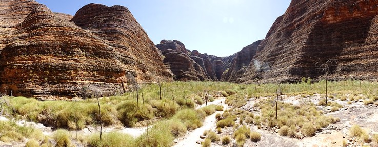
Bacon and egss + percolated coffee later we venture forth to explore the northern section of Purnululu. Purnululu has two tourist-accessible areas, each with several iconic sites to visit: a northern section where the range is largely of massive cliffs with deep gorges and valleys cut into it. And a southern section with Purnululu’s famous ‘bee-hive’ domes, more gorges and a long ten kilometre round-trip walk. They are about 30 km apart. Quite a ride I realise to go from the campsite to the southern sites. And back again. I appreciate even more the stupendous serendipity which just ‘happened’ to put Scott and Evelyn and me in the same outrageously remote place at exactly the same time AND going exactly the same way AND wanting to do exactly the same thing.
The plan for the north section:
- Stonehenge: a nature walk away from Purnululu’s impressive geology describing various plants used by Aboriginals for a variety of reasons from medical to food.
- Homestead Walk: walk along a dry stony river bed into a world of towering sandstone-conglomerate cliffs with hidden-valleys branching off and where, allegedly, an old station homestead used to be, lost now to recycling and the erosive capabilities of nature.
- Echidna Chasm: not sure of the origin of the name given an echidna is an egg-laying mammal similar to a European hedgehog only much, much bigger.
The best time to visit Echidna Chasm is mid to late morning when (some) sunlight manages to penetrate to the chasm floor making the walls glow an ethereal orange.
- Mini-Palm Gorge: includes an extra short walk to Frog Hole. Half-way between Homestead Gorge and Echidna Chasm.
The walks are a mix of prepared track, which is quite easy to walk on, and creek beds with long stretches of soft sand and the rounded boulders and stones of river gravel. Quite a bit harder to walk. I wearing my Keen sandals and the walks make my feet completely black.
Stonehenge is a mild easy walk with info-boards informing us of various species of plants First Nations people used for a variety of things. The First Nations people are unquestionably Masters & Mistresses of a world which at first glance appears hostile, foreboding and something to which a near-naked bipedal Primate is woefully ill-prepared for. And they’ve been successfully living here for tens of thousands of years.

I wonder though, once they made their way across the land bridge between South East Asia – Papua New Guinea to the Cape York Peninsula is the favoured route of the month – and made their way into a land where no primate had ever been before meaning there is no-co-evolution and which had been completely isolated from the entire rest of the world for, like, forty million years! (https://en.wikipedia.org/wiki/Australia_(continent) ).
That means that there would be almost nothing in Australia familiar to those brave Very First Nations people when they wandered in. And, given that Australia has a bewildering array of death-at-any-moment plants, animals, bugs, fish, jellyfish, even small cute easy to catch littoral octopi with pretty blue-rings and even even quite large easy to harvest cone-shaped shells who also possess a harpoon with some of the deadliest venom known to modern-empirically-researched-under-the-strictest-conditions-science, all of which disturbingly occupies most of the Top Ten lists of things which can kill you damned fast, just how long did it take those brave Very First Nations people to become Master & Mistress of Australia. And how many poor buggers suffered a horrible ignominious death? What percentage of those brave Very First Nations people had to perish before they finally had a diverse interesting tasty nutritious diet?
We could not work out the relationship between this walk and the Stonehenge neo-lithic site in England.


Deep in the Homestead walk where it ends overlooking couple of hidden valleys nestled under some very impressive cliffs a bunch of young tourists are a few meters higher than us, moronically throwing stones into the valley presumably enjoying the echo of their impacts. Frankly it’s annoying and I want to ask them what they get out of it. Scott gets in first with a “What’s with the stone throwing? It’s really annoying” to which I add “Yeah, I’d really like to know what you get out of it”. Various mutterings filter down including “Enjoyment” but also “Sorry” and the stones stop flying.


Another stony dry river walk eventually enters a sliver cut through 200 m cliffs less than a meter apart in places. We are in Echidna Chasm. Phenomenal. Hard to get a photo which isn’t a bit blurred since light is at a premium deep in the chasm, but still, had to try. We are just a bit too late to really experience the sunlight on the floor and walls of Echidna Chasm.


The chasm winds for several hundred meters deep into the range. In some places the walls are less than a metre apart and in other areas large silos have been carved out of the sandstone and conglomerates towering above.


After a good couple of hours we exit the chasm just as four bus-loads of tourists descend upon it. Given it’s now early afternoon we try to understand not only why all the tour operators would descend upon a site seriously lacking in space but why they arrive a good three to four hours after the best viewing time.


Next we take on the Mini-Palms walk with its Frog Hole extension. We decide to hunt frogs and walk past the Mini-Palms turn-off. At a dry creek bed there’s a sign which says we’re ‘here’ with a shelter, table and seats. If there’s a place where frogs congregate we cannot identify it.


It is a place of cultural significance. There is a ‘Restricted Access’ sign planted firmly in the middle of the dry creek bed coming from imposing cliffs (they are ONLY imposing cliffs around here). Why, I wonder is there a walk marketed to tourists which simply ends at a shelter with no discernible feature distinguishing it from basically everywhere else but which is in sight of a gorge, which is actually off limits to infidels?


Scott is far more politically correct than I am and declines to ignore the Restricted Access sign and venture up the creek looking for the mystical Frog Hole.
As I wander up the creek I wonder why I’m doing this, ignoring the Restricted Access sign. It is an internal struggle with the exclusiveness of Aboriginal culture, Aboriginal religion. Most of the world’s great religions try to make their values accessible to non-believers in a bid to score some converts. Time has kinda proved, at least to liberal Western cultures that it’s best to separate state from belief. Aboriginal Dreamtime and Songlines are their religion, still utterly inseparable from their culture. No reformation has yet occurred. Given Aboriginal culture, identity and religion are all inextricably intertwined with Country there’s an outstanding chance that every landmark of any significance is going to have cultural importance. This means that what to a non-Aboriginal may be a place of aesthetic beauty may have profound importance culturally/religiously to Aboriginals and therefore be closed to outsiders. Still, it is a religion. What if you don’t believe? What if your values recognise that the water hole would be of immense value to the survival of traditional Aboriginals but ultimately it is just a water hole. Assigning spiritual value to it requires belief. I don’t have that belief. To me it’s just a water hole. One that requires respect and care that any site deserves. In excluding me, as an infidel, from taking part in their culture, even as a spectator, Aborigines are making it hard for me to understand the nuances of their culture and its vulnerability and therefore work towards protecting it.
I don’t dwell up the creek mindful that it is of cultural significance and that Scott and Evelyn are waiting for me back on the path. The wind has picked up too. Perhaps the spirits expressing their displeasure at an infidel being where they shouldn’t. Maybe I shouldn’t be here afterall. I don’t find the mystical frog hole either.


Returning to the path to Mini-Palm Gorge we enter another steep-sided gorge leading to a viewing platform over the end of the gorge. Access to the base of the gorge is also restricted though I’m not sure why. There are no palms, mini or otherwise, in the base of the gorge and I don’t make the effort to ignore the sign and climb my way down.


The Mini-Palms Gorge walk winds up the obligatory stony creek bed before entering towering cliffs. Once through a gap in the cliffs a large area opens up with lots of palm trees, before the cliffs close in again and the path leads to some stairs and a viewing platform over the flat almost bare base where the gorge terminates nestled deep under imposing cliffs. Tourists are forbidden to descend to the gorge’s floor for some unfathomable reason, with a gate preventing access to the track leading down. I wonder about going down there anyway can’t really identify any particularly good reason to. It is but a bare sandy bottom surrounded by giant walls of rock, aside of being a bit rebellious to the relentless sensation of being nannied by the Australian state.


The day largely done we return to camp before heading out again to get some reverse sunset shots of the cliffs overlooking the Stonehenge walk.


5 August 2016
I was a lot more comfortable in my Soulo last night but it didn’t get as cold as the previous night anyway.
Today we take on the southern section and the iconic ‘bee-hive’ formations.


Sites of note in the south include:
- The Dome Loop. A short 700m walk right at the carpark.
- Cathedral Gorge. A huge overhang gouged out by water. A couple of kilometres from the carpark.
- Whip Snake Gorge. A robust 10 kilometre return hike (5 km there, 5 back) heading deep into the bee-hives further on from the Cathedral, taking in the Window which as the names suggests is a hole in a rock.
 Then the vista opens a bit, as we head towards The Cathedral
 There always seems to be a dead tree right smack in the middle of the photo. Everytime. Lovely view regardless
 A Spoonbill vacuuming up the valley floor


The ultimate would be the Picanniny Creek Trek, but that’s a two or three night 30 km hike. We’re not going to do that one.


Unlike the northern section all the sites are aligned along one walk. Albeit with a total of ten kilometres to Whip Snake and back plus the diversions to Cathedral Gorge and a quick detour to The Window.
Getting into it the path simply gets narrower and narrower as the domes and cliffs riser higher and higher, winding deeper into the range. Finally, after a trudge up a bright-white sandy creek-bed the Cathedral opens before us.


Cathedral Gorge is a massive curved overhang carved out of the soft sandstone by millions of years of rainfall. It’s so huge that capturing it in a photo presents no end of challenge and people in the photo are almost invisible, lost among the shear grandeur of it.


It’s cool in the shade and we are all grateful for a break. We’ve another eight or ten kilometres ahead of us. A small pool of water offers no respite since it’s pretty green and slimy.


Back on the path we head towards Whip Snake Gorge enjoying stupendous views over countless Dome islands disappearing into the distance. Back into the full sun and heat radiating off the rocks.


By Australian standards it’s not really hot, early 30s or something. Deep among the domes walking on bright sand and bare rock however extenuates the temperature. It’s a good sweaty walk. Scott is carrying all of the water for Evelyn and himself plus a prodigious amount of photography gear. Like most Australians they are air-conditioner aficionados and don’t really spend hours per day hiking around hot-spots. I on the other hand spend all of my day sweating it out regardless of the temperature or any other weather phenomenon. We take a number of breaks on the walk.


Whip Snake Gorge presumably gets its name from someone’s encounter with a Whip Snake. The lack of information as to the origins of the name suggests whatever the encounter and who got the better deal out of it has been lost in time. If there are Whip Snakes around they are keeping to themselves.
On the other hand spinifex that wonderful eponymous Australian outback grass grows to enormous bundles of spiky tipped joy, in places higher than I. Scott tries to tell me that it’s just growing up a sandbank but I ain’t fooled. That damned spinifex is two meters high.
It’s a bit of a mini-Cathedral. An overhang carved out by water, albeit not quite as grand as The Cathedral. It’s a lot less popular too, which probably has something to do with that 10 km round trip to get here. Again we are grateful for the shade and bit of a cool down.


Back on the path back into the sun. But the sun has changed position altering the landscape, opening new vistas, rendering others which but an hour ago were awesome obsolete. Justification I reason to take more photos. Funny, there’s a bird in the bee-hives which makes a sound just like a ‘tut-tut’.


Three people three cameras three perspectives three ways of approaching a view means we compete for views and The Shot. They are picking on me for taking so many photos. Grossly unfair.


I take a L O T of photos, more than Scott and Evelyn combined. As you may have noticed. It means the walk drags on and on but this may be a once in a life-timer for me so I take every opportunity to record the stupendous views.
The beer back in the carpark was very refreshing. Thank God for car-fridges. And since the beer is but mildly alcoholic there’s no risk of it going to our heads. It’s easy to justify a cold beer when you need to.
But it’s not over yet. We’ve thirty kilometres back to Kurrajong Camp and, surprise surprise there are views that just can’t be ignored, like Elephant Rock. Scott and Evelyn for some reason remain in the car and I, well I snap away. He he.


Kungkalanayi Lookout is tonight’s choice of sunset snaps and a bit of Milky Way Moments. Am getting better at the whole starry-night-photo-thing but am not quite there yet. My Sony DSC-HX90V has great features but isn’t the best when it comes to F-stop (3.5-8 on wide-angle) nor just how long I can keep the shutter open (30 seconds max.). Then there’s this concept about white-balance. Starry night shots are alchemy between F-stop, shutter-speed and white-balance and I haven’t quite worked it all out. Still, fun to try.


Purnululu is quite simply an aesthetic and visual orgy endlessly playing with my senses in endlessly delightful ways. It exceeds even Watarrka. It is also far, far larger than the Red Centre’s visual delights and I could spend days here and still not experience a fraction of it. Awesome.
After three nights we re-load Scott’s Monster and return to the road. Kununurra is a couple of hours drive up the road. Or a solid three-day ride. The terrain whizzes past.

A truly unexpected and really enjoyable change to riding, doing another awesome trip with Scott and Evelyn. Much fun amongst the spectacle of Purnululu.
Max
Kununurra 6 August 2016

Well written once again 🙂
Was really good to catch up and experience Purnululu with you once again.
You did take alot of photos but they are all great images and what else were we going to do?
Evelyn says hi and we both wish you well on your next adventure.
LikeLike
Thanks Scott. The views were amazing and it was great to share the experience with you and Evelyn. I look forward to our next adventure.
Keep on being you and good luck with the time lapse adventures.
M
LikeLike
Wonderful to see it all in those photos. Philippa and myself did a hele-tour over it in the mid 90’s because we dumbly believed the malarky about the road. Should have driven in, and after seeing and reading your story, I’m really sorry we didn’t. Thanks for that, much appreciated.
LikeLike
The road-myth thing is bizarre. The Wolfe Creek road, far far worse. The only reasoning I can fathom is that is has bends, as in tight corners and some short steep inclines and declines and it that Australians are just simply not used to having to turn the steering wheel that tightly that fast (if <15 kph is 'fast' in a car).
LikeLike
My take-home is it’s got nothing to do with “Australians”, who, as you have just described in your previous posts, manage to penetrate pretty well all of the countryside. More likely a method of promoting the various locally run tours. I used to help run a caravan park in a seaside town near a significant natural attraction north of Perth. The local council deliberately left the first five k’s of the access road in appalling condition to discourage self-drivers and all the local businesses went along with it because they operated tours. So, something like that me-thinks. So, once again, thanks for all the photos, really appreciated it.
LikeLike
Yes, I was being a little tongue in cheek. I have thought about the ‘let’s con them’ approach. But that requires a level of collusion which is hard to coordinate. But it does make sense. The thing is though that the road is OK. It’s not a horror track. Another possibility is that a lot of people drive iconic roads but not tracks. The Oodnadatta Track had bugger all traffic. Whereas the Meerenie Loop had lots. The Meerenie has a fierce reputation, for all of 140 km of gravel. Whereas the Oodnadatta doesn’t really have a reputation yet it’s much worse than the Meerenie and goes for like 900 km. I think some people end up on some of these access roads after coming off good roads and consequently find them ‘rough’ thus creating a reputation.
It’s a mystery 60 Minutes should look into.
Glad you like the photos. I took a L O T of them 😉
LikeLike
Time of year mate, from memory wasn’t it all rained out when you were there? I’ve been on the Oodnadatta track in peak hour, a 4WD passing every few minutes, the Pink Roadhouse booked out and the grounds at the springs full of happy campers. We took a day trip from the springs out along some of the Simpson Desert track and it too was bumper to bumper with individuals and groups cutting across to Birdsville. I can’t remember a horizon that didn’t have a car in it. Reminds me, there was a supported bike riding group setting out, the bikes wearing special sand tyres that looked about 10cm wide with chunky tread. 500km of red sand and 30m high dunes, now there’s a challenge !
LikeLike
It was *ucking hot when I was on the Oodnadatta and I guess well out of season. Hardly saw a soul. North of the track, heading towards Finke it rained. I didn’t get rained upon but the north bit did. Sturgess rescued me. We returned along the track and there was no evidence of rain.
About two or three weeks after I’d been through it got closed due to rain.
Seems I was simply not in the season.
The bikes you mention are Fat Boys. Great concept. Am gonna get one for the North (snow). If I ever do the CSR it will be on a fat boy. Keen?
Cheers … M
LikeLike